
Elmore County topographic map
Interactive map
Click on the map to display elevation.
About this map
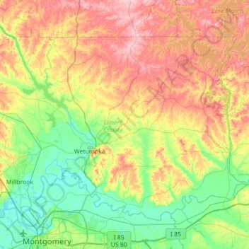
Name: Elmore County topographic map, elevation, terrain.
Location: Elmore County, Alabama, United States of America (32.40603 -86.41328 32.76930 -85.85312)
Average elevation: 113 m
Minimum elevation: 38 m
Maximum elevation: 235 m
Other topographic maps
Click on a map to view its topography, its elevation and its terrain.
Evergreen
United States of America > Alabama > Evergreen
Evergreen, Conecuh County, Alabama, 36401, United States of America
Average elevation: 85 m
Kimberly
United States of America > Alabama > Kimberly
Kimberly, Jefferson County, Alabama, United States of America
Average elevation: 151 m
Northcliff
United States of America > Alabama > Northcliff
Northcliff, Tuscaloosa County, Alabama, 35473, United States of America
Average elevation: 80 m