
Puno topographic map
Interactive map
Click on the map to display elevation.
About this map
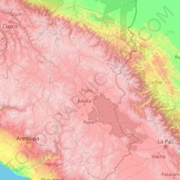
Name: Puno topographic map, elevation, terrain.
Location: Puno, Peru (-17.29525 -71.11809 -13.00413 -68.79549)
Average elevation: 3,150 m
Minimum elevation: 0 m
Maximum elevation: 6,251 m
Other topographic maps
Click on a map to view its topography, its elevation and its terrain.
Cuzco
Cusco or Cuzco (Spanish: [ˈkusko]; Quechua: Qosqo or Qusqu, pronounced [ˈqɔsqɔ]) is a city in southeastern Peru, near the Sacred Valley of the Andes mountain range and the Huatanay river. It is the capital of the eponymous province and department. The city is the seventh most populous in Peru; in 2017, it…
Average elevation: 3,790 m