Geolocate

Door County topographic map

Interactive map

Click on the map to display elevation.

About this map

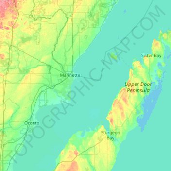
Name: Door County topographic map, elevation, terrain.

Location: Door County, Wisconsin, United States of America (44.67496 -87.73686 45.42985 -86.76396)

Average elevation: 191 m

Minimum elevation: 172 m

Maximum elevation: 315 m

The 102 ft high Brussels Hill (44°45′06″N 87°35′27″W / 44.75166°N 87.59093°W / 44.75166; -87.59093 (Brussels Hill), elevation 851 feet) is the highest point in the county. The nearby Red Hill Woods is the largest remaining maple–beech forest in the area.

Other topographic maps

Click on a map to view its topography, its elevation and its terrain.

Middleton

United States of America > Wisconsin > Middleton

Middleton, Dane County, Wisconsin, 53562, United States of America

Average elevation: 297 m

Gays Mills

United States of America > Wisconsin > Gays Mills

Gays Mills, Crawford County, Wisconsin, United States of America

Average elevation: 272 m

Outagamie County

United States of America > Wisconsin

Outagamie County, Wisconsin, United States of America

Average elevation: 241 m

Waukesha County

United States of America > Wisconsin

Waukesha County, Wisconsin, United States of America

Average elevation: 272 m

Milwaukee County

United States of America > Wisconsin

Milwaukee County, Wisconsin, United States of America

Average elevation: 186 m

Dodgeville

United States of America > Wisconsin > Dodgeville > Dodgeville

Dodgeville, Wisconsin, United States of America

Average elevation: 369 m