
Rockland County topographic map
Interactive map
Click on the map to display elevation.
About this map
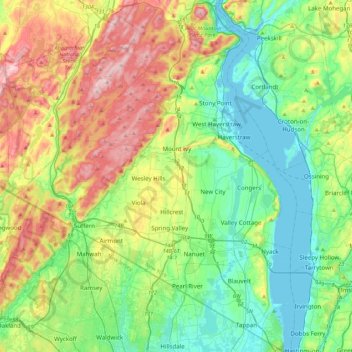
Name: Rockland County topographic map, elevation, terrain.
Location: Rockland County, New York, United States (40.99717 -74.23435 41.32493 -73.88665)
Average elevation: 138 m
Minimum elevation: 0 m
Maximum elevation: 424 m
Other topographic maps
Click on a map to view its topography, its elevation and its terrain.
Pine Neck
United States > New York > Suffolk County > East Quogue > Town of Southampton
Average elevation: 4 m
Mount Van Hoevenberg
United States > New York > Essex County > Town of North Elba
Average elevation: 677 m