
Al Faw topographic map
Interactive map
Click on the map to display elevation.
About this map
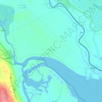
Name: Al Faw topographic map, elevation, terrain.
Location: Al Faw, Al-Basra Governorate, 61010, Iraq (29.90786 47.94478 30.22988 48.61492)
Average elevation: 4 m
Minimum elevation: -6 m
Maximum elevation: 61 m
Other topographic maps
Click on a map to view its topography, its elevation and its terrain.
Al Qurna
Iraq > Al-Basra Governorate > Al Qurna
Al Qurna, Al-Qurnah Central Sbudsitrict, Al-Qurnah District, Al-Basra Governorate, Iraq
Average elevation: 3 m
Shatt al-Arab
Iraq > Al-Basra Governorate > Az Zubayr
Shatt al-Arab, Az Zubayr, Al-Basra Governorate, 601010, Iraq
Average elevation: 8 m