
Helderberg Nature Reserve topographic map
Interactive map
Click on the map to display elevation.
About this map
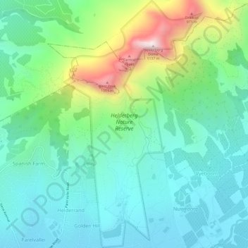
Name: Helderberg Nature Reserve topographic map, elevation, terrain.
Average elevation: 344 m
Minimum elevation: 77 m
Maximum elevation: 1,113 m
Other topographic maps
Click on a map to view its topography, its elevation and its terrain.
Bredell dam
South Africa > Western Cape > City of Cape Town > Somerset West
Bredell dam, Bellaire, Cape Town Ward 15, Somerset West, City of Cape Town, Western Cape, South Africa
Average elevation: 113 m