
Östersund topographic map
Interactive map
Click on the map to display elevation.
About this map
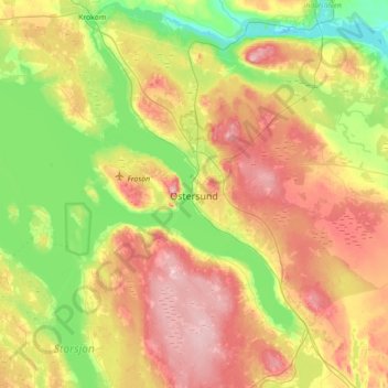
Name: Östersund topographic map, elevation, terrain.
Average elevation: 341 m
Minimum elevation: 248 m
Maximum elevation: 474 m
Though Östersund is in fact affected by the gulf stream it lacks the high frequency of rain following the currents. This is due to the Scandinavian Mountain Range acting as a natural barrier, receiving most of the precipitation, giving Östersund and the surrounding area a rain deficit. Another issue that has to be taken into account is the higher elevation of Östersund compared to the weather stations in Ångermanland farther east. For example, Sollefteå at a similar latitude 130 kilometres (81 mi) to the east but at sea level, albeit inland, has almost three degrees warmer July days.