
Muş merkez topographic map
Interactive map
Click on the map to display elevation.
About this map
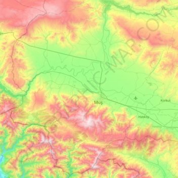
Name: Muş merkez topographic map, elevation, terrain.
Location: Muş merkez, Muş, Eastern Anatolia Region, Turkey (38.48299 41.10942 39.06939 41.88229)
Average elevation: 1,650 m
Minimum elevation: 913 m
Maximum elevation: 2,806 m
Other topographic maps
Click on a map to view its topography, its elevation and its terrain.
Kars merkez
Turkey > Eastern Anatolia Region
Kars merkez, Kars, Eastern Anatolia Region, Turkey
Average elevation: 1,894 m
Muş
Turkey > Eastern Anatolia Region > Muş
Muş, Muş merkez, Muş, Eastern Anatolia Region, 49001, Turkey
Average elevation: 1,590 m