
Ontonagon County topographic map
Interactive map
Click on the map to display elevation.
About this map
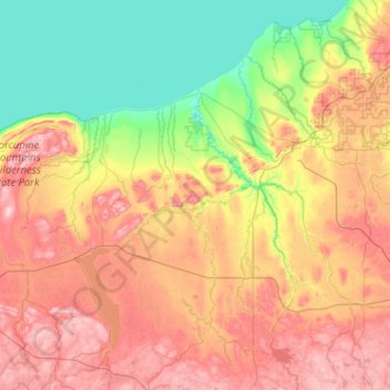
Name: Ontonagon County topographic map, elevation, terrain.
Location: Ontonagon County, Michigan, United States of America (46.33230 -89.88806 47.03128 -88.86374)
Average elevation: 334 m
Minimum elevation: 174 m
Maximum elevation: 587 m
Other topographic maps
Click on a map to view its topography, its elevation and its terrain.
Saint Joseph County
United States of America > Michigan
Saint Joseph County, Michigan, United States of America
Average elevation: 262 m
Leelanau County
United States of America > Michigan
Leelanau County, Michigan, United States of America
Average elevation: 185 m
Bay City
United States of America > Michigan > Bay City
Bay City, Bay County, Michigan, 48708, United States of America
Average elevation: 182 m
Ingham County
United States of America > Michigan
Ingham County, Michigan, United States of America
Average elevation: 278 m
Shiawassee County
United States of America > Michigan
Shiawassee County, Michigan, United States of America
Average elevation: 241 m
Ludington
United States of America > Michigan > Ludington
Ludington, Mason County, Michigan, United States of America
Average elevation: 184 m
Lake Saint Clair
United States of America > Michigan > Waldenburg
Lake Saint Clair, Hall Road, Waldenburg, Macomb Township, Macomb County, Michigan, 48044, United States of America
Average elevation: 177 m
Grand Traverse County
United States of America > Michigan
Grand Traverse County, Michigan, United States of America
Average elevation: 246 m
Baraga County
United States of America > Michigan
Baraga County, Michigan, United States of America
Average elevation: 378 m
East Lansing
United States of America > Michigan > East Lansing
East Lansing, Ingham County, Michigan, United States of America
Average elevation: 261 m
Sanilac County
United States of America > Michigan
Sanilac County, Michigan, United States of America
Average elevation: 228 m