
Caledon River topographic map
Interactive map
Click on the map to display elevation.
About this map
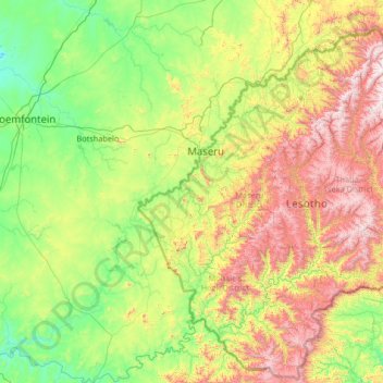
Name: Caledon River topographic map, elevation, terrain.
Location: Caledon River, Lesotho (-30.52372 26.06561 -28.57057 28.70329)
Average elevation: 1,728 m
Minimum elevation: 1,245 m
Maximum elevation: 3,213 m
Other topographic maps
Click on a map to view its topography, its elevation and its terrain.
Maboloka
Lesotho > Qacha's Nek District > Ha Kali
Maboloka, Ha Kali, Qacha's Nek District, Lesotho
Average elevation: 2,312 m
Tokoza (Lekeishini-le-Moyama)
Tokoza (Lekeishini-le-Moyama), Mokhotlong District, Lesotho
Average elevation: 3,039 m
Moeaneng
Moeaneng, Mokhotlong District, Lesotho
Average elevation: 2,268 m
Drakensberg
Drakensberg, Mokhotlong District, Lesotho
Average elevation: 3,286 m
Nqechane
Lesotho > Leribe District > Nqechane Ha-Setjeo
Nqechane, Nqechane Ha-Setjeo, Leribe District, Lesotho
Average elevation: 1,646 m
Ha Motheo
Lesotho > Maseru District > Temaneng
Ha Motheo, Temaneng, Maseru District, Lesotho
Average elevation: 1,779 m
KOLO - Ha-Ntsie
KOLO - Ha-Ntsie, Mafeteng District, Lesotho
Average elevation: 1,515 m
Mohlakeng
Lesotho > Maseru District > Moriting
Mohlakeng, Ha Matebesi, Moriting, Ha Tsiu, Maseru District, Lesotho
Average elevation: 1,543 m
Moyeni (Quthing)
Moyeni (Quthing), Quthing District, Lesotho
Average elevation: 1,644 m
Katse Dam
Lesotho > Thaba-Tseka District
Katse Dam, Thaba-Tseka District, Lesotho
Average elevation: 2,108 m
Bakenkop
Lesotho > Mohale's Hoek District
Bakenkop, Mohale's Hoek District, Lesotho
Average elevation: 1,829 m
Maputsoe
Lesotho > Mokhotlong District > Maputsoe
Maputsoe, Mokhotlong District, Lesotho
Average elevation: 2,440 m
Ha-Maputsoe
Lesotho > Leribe District > Ha-Maputsoe
Ha-Maputsoe, Leribe District, Lesotho
Average elevation: 1,600 m
Ha Khoalipane
Lesotho > Qacha's Nek District > Ha Khoalipane
Ha Khoalipane, Qacha's Nek District, Lesotho
Average elevation: 1,710 m
Maseru
Maseru, Ha Tsiu, Maseru District, 100, Lesotho
Average elevation: 1,606 m
Ha-Foso
Lesotho > Berea District > Ha-Foso
Ha-Foso, Berea District, 75038, Lesotho
Average elevation: 1,594 m
Tsetsana
Lesotho > Berea District > Matebeleng > Tsetsana
Tsetsana, Matebeleng, Berea District, Lesotho
Average elevation: 1,811 m
Mont-aux-Sources
Mont-aux-Sources, Mokhotlong District, Lesotho
Average elevation: 3,113 m
Bela Bela
Lesotho > Berea District > bela bela
Bela Bela, Berea District, Lesotho
Average elevation: 1,729 m
Riet Vlei
Lesotho > Mohale's Hoek District > Riet Vlei
Riet Vlei, Mohale's Hoek District, Lesotho
Average elevation: 1,535 m
Village group Malealea
Lesotho > Mafeteng District > Village group Malealea
Village group Malealea, Mafeteng District, Lesotho
Average elevation: 1,742 m
Sehlabathebe National Park
Lesotho > Qacha's Nek District
Sehlabathebe National Park, Qacha's Nek District, Lesotho
Average elevation: 2,331 m
Thaba Bosiu
Lesotho > Maseru District > Thaba Bosiu
Thaba Bosiu, Maseru District, Lesotho
Average elevation: 1,625 m
Thabana Ntlenyana
Thabana Ntlenyana, Mokhotlong District, Lesotho
Average elevation: 3,313 m
bela bela
Lesotho > Berea District > bela bela
bela bela, Berea District, Lesotho
Average elevation: 1,781 m