
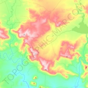
Emalahleni Ward 2 topographic map
Interactive map
Click on the map to display elevation.
About this map
Name: Emalahleni Ward 2 topographic map, elevation, terrain.
Average elevation: 1,080 m
Minimum elevation: 822 m
Maximum elevation: 1,504 m
Other topographic maps
Click on a map to view its topography, its elevation and its terrain.
Emalahleni Ward 14
RSA > Eastern Cape > Emalahleni Local Municipality
Emalahleni Ward 14, Emalahleni Local Municipality, Chris Hani District Municipality, Eastern Cape, RSA
Average elevation: 1,560 m
Xonxa Dam
RSA > Eastern Cape > Emalahleni Local Municipality
Xonxa Dam, Emalahleni Ward 1, Emalahleni Local Municipality, Chris Hani District Municipality, Eastern Cape, RSA
Average elevation: 1,037 m
Ntabankulu
RSA > Eastern Cape > Emalahleni Local Municipality
Ntabankulu, Emalahleni Local Municipality, Chris Hani District Municipality, Eastern Cape, RSA
Average elevation: 1,090 m