
Golden Gate Highlands National Park topographic map
Interactive map
Click on the map to display elevation.
About this map
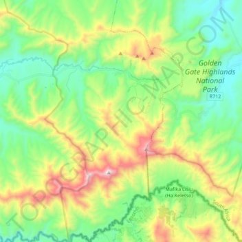
Name: Golden Gate Highlands National Park topographic map, elevation, terrain.
Average elevation: 2,065 m
Minimum elevation: 1,697 m
Maximum elevation: 2,819 m
Other topographic maps
Click on a map to view its topography, its elevation and its terrain.
Dihlabeng Ward 20
RSA > Free State > Dihlabeng Local Municipality
Dihlabeng Ward 20, Dihlabeng Local Municipality, Thabo Mofutsanyana District Municipality, Free State, 9707, RSA
Average elevation: 1,975 m
Swartkrans
RSA > Free State > Dihlabeng Local Municipality
Swartkrans, Dihlabeng Local Municipality, Thabo Mofutsanyana District Municipality, Free State, RSA
Average elevation: 2,036 m