
KwaDuma topographic map
Interactive map
Click on the map to display elevation.
About this map
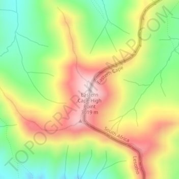
Name: KwaDuma topographic map, elevation, terrain.
Location: KwaDuma, Quthing District, Lesotho (-30.46661 28.15582 -30.46651 28.15592)
Average elevation: 2,798 m
Minimum elevation: 2,595 m
Maximum elevation: 3,025 m
Other topographic maps
Click on a map to view its topography, its elevation and its terrain.
Moyeni (Quthing)
Moyeni (Quthing), Quthing District, Lesotho
Average elevation: 1,644 m