
The Crags topographic map
Interactive map
Click on the map to display elevation.
About this map
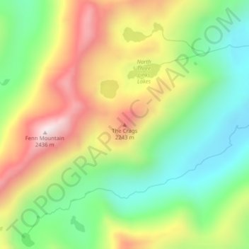
Name: The Crags topographic map, elevation, terrain.
Location: The Crags, Idaho County, Idaho, United States of America (46.17792 -115.19212 46.17802 -115.19202)
Average elevation: 2,008 m
Minimum elevation: 1,698 m
Maximum elevation: 2,423 m
Other topographic maps
Click on a map to view its topography, its elevation and its terrain.
American Falls
United States of America > Idaho > American Falls
American Falls is located at 42°46′52″N 112°51′20″W / 42.78111°N 112.85556°W / 42.78111; -112.85556 (42.781121, -112.855694), at an elevation of 4,406 feet (1,343 m).
Average elevation: 1,346 m