
Daneș topographic map
Interactive map
Click on the map to display elevation.
About this map
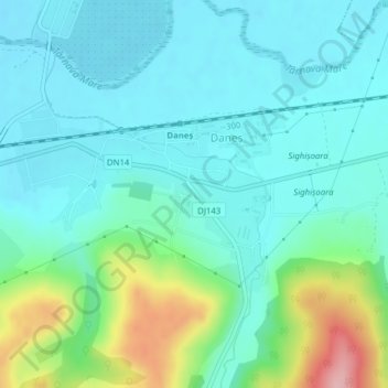
Name: Daneș topographic map, elevation, terrain.
Location: Daneș, Mureș, Romania (46.21474 24.68694 46.22555 24.71179)
Average elevation: 363 m
Minimum elevation: 326 m
Maximum elevation: 493 m
Other topographic maps
Click on a map to view its topography, its elevation and its terrain.
Târgu Mureș
Târgu Mureș, Targu Mures Metropolitan Area, Mureș, Romania
Average elevation: 357 m
Lac de Acumulare Sântămăria-Orlea
Lac de Acumulare Sântămăria-Orlea, Nălațvad, Hateg, Hunedoara, 335501, Romania
Average elevation: 328 m
Sălașu de Sus
Sălașu de Sus, Hunedoara, 337420, Romania
Average elevation: 491 m
Danube Delta Biosphere Reserve
Danube Delta Biosphere Reserve, Tulcea, 827051, Romania
Average elevation: 3 m
Retezat National Park
Retezat National Park, Hunedoara, Romania
Average elevation: 1,443 m