
Negeri Sembilan topographic map
Interactive map
Click on the map to display elevation.
About this map
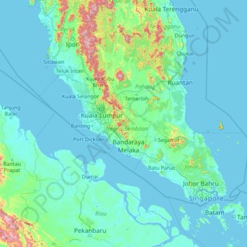
Name: Negeri Sembilan topographic map, elevation, terrain.
Location: Negeri Sembilan, Malaysia (0.28080 99.59408 5.40080 104.71408)
Average elevation: 92 m
Minimum elevation: -3 m
Maximum elevation: 2,087 m
Other topographic maps
Click on a map to view its topography, its elevation and its terrain.
Port Dickson
Port Dickson, Negeri Sembilan, 71000, Malaysia
Average elevation: 12 m
Pasir Panjang
Malaysia > Negeri Sembilan > Pasir Panjang
Pasir Panjang, Negeri Sembilan, 71250, Malaysia
Average elevation: 9 m