
Bagmati topographic map
Interactive map
Click on the map to display elevation.
About this map
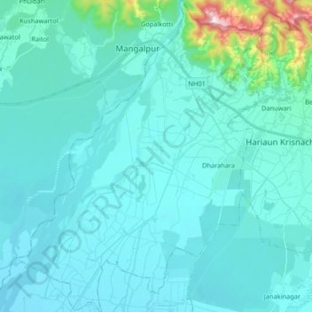
Name: Bagmati topographic map, elevation, terrain.
Location: Bagmati, Sarlahi, Province #2, Nepal (27.00916 85.40249 27.15466 85.53330)
Average elevation: 148 m
Minimum elevation: 92 m
Maximum elevation: 660 m
Other topographic maps
Click on a map to view its topography, its elevation and its terrain.
Khumjung
Nepal > Koshi Province > Solukhumbu
Khumjung (Nepali: खुम्जुंग) is a village in Khumbu Pasanglhamu rural municipality of Solukhumbu District in Province No. 1 of north-eastern Nepal. It is located in the Khumbu subregion inside Sagarmatha National Park, a world heritage site. The village is at an elevation of 3,790 metres above…
Average elevation: 3,888 m
Mount Everest
Nepal > Koshi Province > Solukhumbu
Mount Everest (Nepali: सगरमाथा, romanized: Sagarmāthā; Tibetan: Chomolungma ཇོ་མོ་གླང་མ; Chinese: 珠穆朗玛峰; pinyin: Zhūmùlǎngmǎ Fēng) is Earth's highest mountain above sea level, located in the Mahalangur Himal sub-range of the Himalayas. The China–Nepal…
Average elevation: 7,850 m