Geolocate

Piura topographic map

Interactive map

Click on the map to display elevation.

Piura

Topography is smooth in the coast and rough in the Sierra. There are many arid plains in the southern region. The Sechura Desert, located south of the Piura River, is Peru's largest desert and one of the world's few examples of a tropical desert; it borders a tropical terrain to the north. The Bayóvar Depression, which is the lowest point in Peru and all of the Southern Tropics, is located in this desert.

Wikipedia (CC-BY-SA 3.0)

About this map

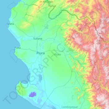
Name: Piura topographic map, elevation, terrain.

Location: Piura, Peru (-6.37209 -81.32840 -4.07933 -79.21033)

Average elevation: 675 m

Minimum elevation: -25 m

Maximum elevation: 4,013 m

Other topographic maps

Click on a map to view its topography, its elevation and its terrain.

Cuzco

Peru > Cusco

Cusco is the seventh-most populous city in Peru; in 2017, it had a population of 428,450. It is also the largest city in the Peruvian Andes and the region is the seventh-most populous metropolitan area of Peru. Its elevation is around 3,400 m (11,200 ft). The largest district in the city is the Cusco District,…

Average elevation: 3,790 m

Machu Picchu

Peru > Cusco > Machupicchu > San Miguel

Animals are also suspected to have immigrated to Machu Picchu as there were several bones found that were not native to the area. Most animal bones found were from llamas and alpacas. These animals naturally live at altitudes of 4,000 metres (13,000 ft) rather than the 2,400 metres (7,900 ft) elevation of…

Average elevation: 2,227 m

fuego

Peru > Ica > Vista Alegre

Average elevation: 925 m

Caymo

Peru > Huancavelica > Salcabamba

Average elevation: 3,119 m

San Alejandro

Peru > Loreto > Mazán

Average elevation: 85 m

Puerto Azul

Peru > Ucayali > Padre Abad

Average elevation: 338 m

Mocupe

Peru > Lambayeque

Average elevation: 35 m

Unya

Peru > Ayacucho

Average elevation: 2,927 m

Cansas

Peru > Ica > Yauca del Rosario

Average elevation: 1,183 m

Quebrada Verde

Peru > Lima

Average elevation: 173 m

Miguel Grau

Peru > Junín > Perené

Average elevation: 1,322 m

Parque Simón Bolivar

Peru > Arequipa > Arequipa

Average elevation: 2,318 m

Plaza

Peru > Huánuco > José Crespo y Castillo > Aucayacu

Average elevation: 564 m

San Miguel

Peru > Cusco > Machupicchu > Intihuatana

Average elevation: 2,262 m

Sahuasiray

Peru > Cusco > Calca

Average elevation: 5,103 m

Salcantay

Peru > Cusco > Cuzco

Average elevation: 4,001 m

Jirishanca

Peru > Ancash > Pacllón

The altitude of 6125 isn't likely as other data from available digital elevation models show lower elevations: SRTM yields 6028 metres and TanDEM-X 5734 metres. The height of the nearest key col is 5610 meters, leading to a topographic prominence of 484 meters. Jirishanca is considered a Mountain according to…

Average elevation: 5,198 m

Tinajani

Peru > Puno > Ayaviri

Average elevation: 4,090 m

Vilquechico

Peru > Puno > Vilque Chico

Average elevation: 3,933 m

Picoy

Peru > Junín > Acobamba

Average elevation: 3,454 m

Huancahuasi

Peru > Lima

Average elevation: 3,693 m

3EA

Peru > Arequipa > Majes > El Pedregal

Average elevation: 1,400 m

El Cardon

Peru > Cajamarca > Cutervo

Average elevation: 2,316 m

Tambulla

Peru > Apurímac > Challhuahuacho

Average elevation: 3,954 m

Centro America

Peru > Loreto > Balas Puerto

Average elevation: 155 m

Vinicunca

Peru > Cusco > Cusipata

Vinicunca, or Winikunka, also called Montaña de Siete Colores (literally: Mountain of seven colors), Montaña de Colores (Mountain of colors) or Montaña Arcoíris (Rainbow Mountain), is a mountain in the Andes of Peru with an altitude of 5,036 metres (16,522 ft) above sea level. It is located on the road to…

Average elevation: 4,874 m

Casual

Peru > Amazonas > Bagua

Average elevation: 440 m

Puerto Azul

Peru > Ucayali > Padre Abad

Average elevation: 338 m

Prusia

Peru > Pasco > Pozuzo

Average elevation: 989 m

entrada al ingenio

Peru > Ica > San Miguel de la Pascana

Average elevation: 400 m

La Rinconada

Peru > Puno

The town has gained notoriety for its extreme living conditions that include its high rates of altitude sickness, pollution, poverty, murder, and sex trafficking, and as a result has sometimes been referred to in Spanish as la ciudad sin ley del Perú, which means "the lawless city of Peru".

Average elevation: 4,923 m

Yurayaco

Peru > Ancash

Average elevation: 3,537 m

Ivochote

Peru > Cusco > Echarate

Average elevation: 875 m

Lizard

Peru > Ica > El Ingenio

Average elevation: 468 m

55J

Peru > Lima

Average elevation: 315 m

Lima

Peru > Lima

The suburban district of Cieneguilla, the district of Pachacámac and the district of Chosica provide important tourist attractions among locals. Due to its elevation (over 500 masl), the sun shines in Chosica during the winter, being very visited by the residents of Lima to escape the urban fog.

Average elevation: 202 m

Tapoje

Peru > Puno > Yunguyo

Average elevation: 3,838 m

Sapalache

Peru > Piura > El Carmen de la Frontera

Average elevation: 2,478 m

Jilili

Peru > Piura > Jililí

Average elevation: 1,561 m

Parón Lake

Peru > Ancash > Caraz

Average elevation: 4,483 m

Sicchez

Peru > Piura > Sícchez

Average elevation: 1,565 m

Santa Cruz

Peru > Cajamarca

Average elevation: 511 m

Tumbes

Peru > Tumbes > District of Tumbes

Average elevation: 41 m

San José

Peru > Lima > Aucallama

Average elevation: 164 m

Parque Villa Corpac

Peru > Lima

Average elevation: 191 m

Acotama

Peru > Lima > Ihuarí

Average elevation: 1,627 m

Zorritos

Peru > Tumbes > District of Zorritos

Average elevation: 32 m

Sullia

Peru > Cusco > Tinta

Average elevation: 3,693 m

2 de Mayo

Peru > Ucayali > Yarinacocha

Average elevation: 149 m

Mayascón

Peru > Lambayeque

Average elevation: 402 m

Puerto Luz

Peru > Madre de Dios > Madre de Dios

Average elevation: 270 m

Callejon de Huaylas

Peru > Ica > Santiago > Mayuries

Average elevation: 388 m

2W

Peru > Lima

Average elevation: 313 m

Los Jagueyes de Mayascón

Peru > Lambayeque > Pítipo

Average elevation: 555 m

Humacchuco

Peru > Ancash > Yungay

Average elevation: 3,345 m

Millu

Peru > Apurímac > Oropesa

Average elevation: 4,853 m

Soraypampa

Peru > Cusco > Mollepata

Average elevation: 4,367 m

Colana

Peru > Moquegua > Carumas > Ataspaya

Average elevation: 3,046 m

Abra La Raya

Peru > Cusco > Layo

Average elevation: 4,568 m

Vicos

Peru > Ancash > Marcará

Average elevation: 4,908 m

El Salto

Peru > Piura > Tambo Grande

Average elevation: 73 m

Puruchuco

Peru > Apurímac > Antabamba

Average elevation: 4,105 m

Mejia

Peru > Piura > Sullana

Average elevation: 77 m

Pauchi

Peru > Apurímac > Haquira > Marcallac

Average elevation: 3,950 m

5D

Peru > Lima

Average elevation: 316 m

Bentrellata

Peru > Moquegua > Moquegua

Average elevation: 1,261 m

Pucallpa

Peru > Ucayali

Average elevation: 146 m

Nevado Mismi

Peru > Arequipa > Lari

The Upper Amazon expedition (The Flying Expedition) included an Eastern European multi-axled articulated Land Rover for use on land, a float plane Papagaiu, for air support and reconnaissance, and the Peruvian Air Force offered a high elevation helicopter to reach the upper levels of the Chila mountain range…

Average elevation: 5,273 m

San Rogue

Peru > Loreto

Average elevation: 104 m

Huaruchaca

Peru > Apurímac > Mamara

Average elevation: 3,598 m

N

Peru > Lima

Average elevation: 147 m

Bandolista

Peru > Cusco > Mandolista

Average elevation: 3,234 m

Caral

Peru > Lima > Supe

Average elevation: 467 m

Santa Clemencia

Peru > Ancash > Chimbote

Average elevation: 91 m

3S

Peru > Lima

Average elevation: 329 m

Cambio Puente

Peru > Ancash > Chimbote

Average elevation: 109 m

Nueva Esperanza

Peru > La Libertad

Average elevation: 39 m

Laguna Llaca

Peru > Ancash > Independencia

Average elevation: 4,835 m

Quenuayoc

Peru > Ancash > Independencia > Paccha

Average elevation: 3,379 m

Ticlla

Peru > Arequipa > Chachas

Average elevation: 5,074 m

La Restinga

Peru > Ucayali > Yarinacocha

Average elevation: 142 m

Punta Lomitas

Peru > Ica > Ocucaje

Average elevation: 13 m

Lacasmayo

Peru > Lima > Gantuyoc

Average elevation: 3,931 m

Tingo María

Peru > Huánuco

Tingo María was considered unreachable until 1936, when the Montaña Road reached the settlement. It was then that the state run Estacion Experimental Agricola was established due to its "comfortable" elevation (2,204 ft). In 1942, the U.S. Government began adding more funding to the station, and by 1960 over…

Average elevation: 841 m

El Milagro

Peru > La Libertad

Average elevation: 151 m

Laguna Palcacocha

Peru > Ancash > Independencia

Palcacocha is located at 9°23′49″S 77°22′47″W / 9.39694°S 77.37972°W / -9.39694; -77.37972 in the Ancash Region in Cordillera Blanca at an elevation of 4,566 m, just below the summits of Palcaraju (6,274 m) and Pucaranra (6,156 m). The lake is one of several lakes supplying the town Huaraz…

Average elevation: 4,857 m

Caral

Peru > Lima > Supe

Average elevation: 467 m

Piscopampa

Peru > La Libertad

Average elevation: 3,242 m

Santa Rosa

Peru > Ayacucho > San Juan Bautista

Average elevation: 2,792 m

Huaycán de Cieneguilla

Peru > Lima > Cieneguilla

Average elevation: 555 m

Cuchapampa

Peru > Amazonas > Tingo

Average elevation: 2,681 m

Punta Lomitas

Peru > Ica > Ocucaje

Average elevation: 13 m

San Martin de Paras

Peru > Ancash > Mirgas

Average elevation: 3,659 m

Chacpar

Peru > Ancash > Chavín de Huantar

Average elevation: 3,907 m

Huasaccata

Peru > Puno > Paucarcolla

Average elevation: 3,837 m

La Victoria

Peru > Ancash > Huarmey

Average elevation: 24 m

Guitarrayoc

Peru > Ayacucho > Uspa

Average elevation: 1,516 m