
Piura topographic map
Interactive map
Click on the map to display elevation.
Piura
Topography is smooth in the coast and rough in the Sierra. There are many arid plains in the southern region. The Sechura Desert, located south of the Piura River, is Peru's largest desert and one of the world's few examples of a tropical desert; it borders a tropical terrain to the north. The Bayóvar Depression, which is the lowest point in Peru and all of the Southern Tropics, is located in this desert.
About this map
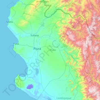
Name: Piura topographic map, elevation, terrain.
Location: Piura, Peru (-6.37209 -81.32840 -4.07933 -79.21033)
Average elevation: 675 m
Minimum elevation: -25 m
Maximum elevation: 4,013 m
Other topographic maps
Click on a map to view its topography, its elevation and its terrain.
Cuzco
Cusco or Cuzco (Spanish: [ˈkusko]; Quechua: Qosqo or Qusqu, pronounced [ˈqɔsqɔ]) is a city in southeastern Peru, near the Sacred Valley of the Andes mountain range and the Huatanay river. It is the capital of the eponymous province and department. The city is the seventh most populous in Peru; in 2017, it…
Average elevation: 3,790 m
Machu Picchu
Peru > Cusco > Machupicchu > San Miguel
Animals are also suspected to have immigrated to Machu Picchu as there were several bones found that were not native to the area. Most animal bones found were from llamas and alpacas. These animals naturally live at altitudes of 4,000 metres (13,000 ft) rather than the 2,400 metres (7,900 ft) elevation of…
Average elevation: 2,227 m
Lima
The suburban district of Cieneguilla, the district of Pachacámac and the district of Chosica provide important tourist attractions among locals. Due to its elevation (over 500 masl), the sun shines in Chosica during the winter, being very visited by the residents of Lima to escape the urban fog.
Average elevation: 202 m
Viewpoint crack in mountains shaped like the map of Peru
Average elevation: 4,202 m
Nevado Mismi
The Upper Amazon expedition (The Flying Expedition) included an Eastern European multi-axled articulated Land Rover for use on land, a float plane Papagaiu, for air support and reconnaissance, and the Peruvian Air Force offered a high elevation helicopter to reach the upper levels of the Chila mountain range…
Average elevation: 5,273 m
Laguna Palcacocha
Peru > Ancash > Independencia
Palcacocha is located at 9°23′49″S 77°22′47″W / 9.39694°S 77.37972°W / -9.39694; -77.37972 in the Ancash Region in Cordillera Blanca at an elevation of 4,566 m, just below the summits of Palcaraju (6,274 m) and Pucaranra (6,156 m). The lake is one of several lakes supplying the town Huaraz…
Average elevation: 4,857 m
Tingo María
Tingo María was considered unreachable until 1936, when the Montaña Road reached the settlement. It was then that the state run Estacion Experimental Agricola was established due to its "comfortable" elevation (2,204 ft). In 1942, the U.S. Government began adding more funding to the station, and by 1960 over…
Average elevation: 841 m
Cuzco
Cusco or Cuzco (Latin American Spanish: [ˈkusko]; Quechua: Qosqo or Qusqu, both pronounced [ˈqosqɔ]) is a city in southeastern Peru, near the Sacred Valley of the Andes mountain range and the Huatanay river. It is the capital of the eponymous province and department. The city is the seventh most populous in…
Average elevation: 3,790 m