
Shigatse Prefecture topographic map
Interactive map
Click on the map to display elevation.
About this map
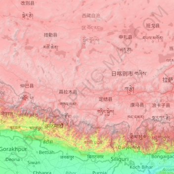
Name: Shigatse Prefecture topographic map, elevation, terrain.
Location: Shigatse Prefecture, Tibet, China (27.21205 82.09907 31.80997 90.34500)
Average elevation: 3,772 m
Minimum elevation: 23 m
Maximum elevation: 8,097 m
Shigatse Peace Airport began operations on 30 October 2010 after an Airbus A319 landed safely, making it Tibet's fifth commercial airport. It is located 43 kilometres from Samzhubzê District at Jangdam Township at an elevation of 3,782 metres. The airport will be capable of supporting 230,000 passengers annually by 2020.
Other topographic maps
Click on a map to view its topography, its elevation and its terrain.
Chengguan District
Chengguan District, Lhasa, Tibet, 850000, China
Average elevation: 4,325 m
Gadong
China > Tibet > Bainang County > Gadong
Gadong, Bainang County, Shigatse, Tibet, China
Average elevation: 4,127 m