
Mount Wilson topographic map
Interactive map
Click on the map to display elevation.
About this map
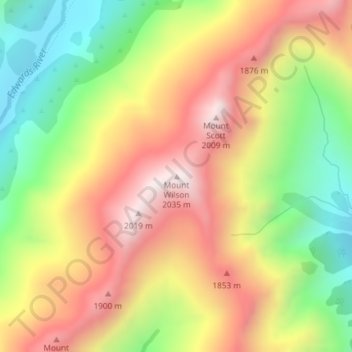
Name: Mount Wilson topographic map, elevation, terrain.
Location: Mount Wilson, Selwyn District, Canterbury, New Zealand (-42.93181 171.67845 -42.93171 171.67855)
Average elevation: 1,569 m
Minimum elevation: 1,111 m
Maximum elevation: 2,018 m
Other topographic maps
Click on a map to view its topography, its elevation and its terrain.
Halswell-Hornby-Riccarton Community
New Zealand > Canterbury > Christchurch City
Average elevation: 49 m