
Phuket Province topographic map
Interactive map
Click on the map to display elevation.
About this map
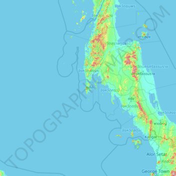
Name: Phuket Province topographic map, elevation, terrain.
Location: Phuket Province, Thailand (5.37660 95.79293 10.49660 100.91293)
Average elevation: 24 m
Minimum elevation: -3 m
Maximum elevation: 1,611 m
Although some recent geographical works refer to the sections of the Tenasserim Hills in the isthmus as the "Phuket Range", these names are not found in classical geographic sources. Besides, the name Phuket is relatively recent having previously been named Jung Ceylon and Thalang. The highest elevation of the island is usually regarded as Khao Mai Thao Sip Song (Twelve Canes), at 529 metres (1,736 ft) above sea level. However, it has been reported by barometric pressure readings that there is an even higher elevation (with no apparent name), of 542 meters above sea level, in the Kamala hills behind Kathu waterfall.
Other topographic maps
Click on a map to view its topography, its elevation and its terrain.
Kathu
Thailand > Phuket Province > Kathu
Kathu, Phuket Province, 83120, Thailand
Average elevation: 133 m
Big Kathu
Thailand > Phuket Province > Phuket
Big Kathu, Phuket, Phuket Province, 83120, Thailand
Average elevation: 237 m