Geolocate

Mayotte topographic map

Interactive map

Click on the map to display elevation.

About this map

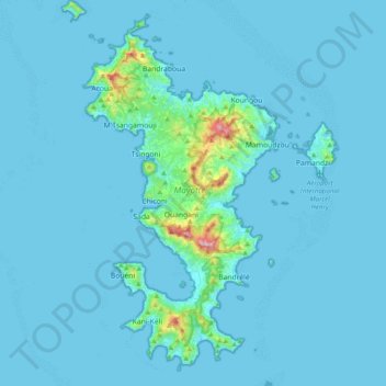
Name: Mayotte topographic map, elevation, terrain.

Location: Mayotte, France (-13.02101 45.01833 -12.63659 45.29999)

Average elevation: 27 m

Minimum elevation: 0 m

Maximum elevation: 609 m

Other topographic maps

Click on a map to view its topography, its elevation and its terrain.

Réserve Naturelle de l'îlot Mbouzi

France > Mayotte > Mamoudzou

Réserve Naturelle de l'îlot Mbouzi, Boulevard Mawana-Madi, Mamoudzou, Mayotte, 97600, France

Average elevation: 5 m