
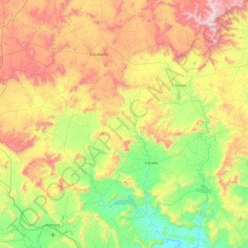
Emalahleni Local Municipality topographic map
Interactive map
Click on the map to display elevation.
About this map
Name: Emalahleni Local Municipality topographic map, elevation, terrain.
Average elevation: 1,432 m
Minimum elevation: 805 m
Maximum elevation: 2,508 m
Other topographic maps
Click on a map to view its topography, its elevation and its terrain.
Komani
South Africa > Eastern Cape > Chris Hani District Municipality > Lukhanji Local Municipality
Average elevation: 1,147 m
Mount Shepstone
South Africa > Eastern Cape > Chris Hani District Municipality > Lukhanji Local Municipality
Average elevation: 1,701 m
Ngcobo
South Africa > Eastern Cape > Chris Hani District Municipality > Engcobo Local Municipality
Average elevation: 950 m
Komani
South Africa > Eastern Cape > Chris Hani District Municipality > Lukhanji Local Municipality
Average elevation: 1,147 m
Cofimvaba
South Africa > Eastern Cape > Chris Hani District Municipality > Intsika Yethu Local Municipality
Average elevation: 997 m
Macubeni Dam
South Africa > Eastern Cape > Chris Hani District Municipality > Emalahleni Local Municipality
Average elevation: 1,347 m
Komani
South Africa > Eastern Cape > Chris Hani District Municipality > Lukhanji Local Municipality > Komani
Average elevation: 1,064 m
Cofimvaba
South Africa > Eastern Cape > Chris Hani District Municipality > Intsika Yethu Local Municipality
Average elevation: 997 m
Komani
South Africa > Eastern Cape > Chris Hani District Municipality > Lukhanji Local Municipality
Average elevation: 1,147 m
Molteno
South Africa > Eastern Cape > Chris Hani District Municipality > Inkwanca Local Municipality
Average elevation: 1,640 m
Tsojana Dam
South Africa > Eastern Cape > Chris Hani District Municipality > Intsika Yethu Local Municipality > Mkwezweni
Average elevation: 1,131 m
Cofimvaba
South Africa > Eastern Cape > Chris Hani District Municipality > Intsika Yethu Local Municipality
Average elevation: 997 m
Cradock
South Africa > Eastern Cape > Chris Hani District Municipality > Inxuba Yethemba Local Municipality
Average elevation: 940 m
Khowa (Elliot)
South Africa > Eastern Cape > Chris Hani District Municipality > Sakhisizwe Local Municipality
Average elevation: 1,497 m
Macubeni Dam
South Africa > Eastern Cape > Chris Hani District Municipality > Emalahleni Local Municipality
Average elevation: 1,347 m
Komani
South Africa > Eastern Cape > Chris Hani District Municipality > Lukhanji Local Municipality
Average elevation: 1,147 m
Khowa (Elliot)
South Africa > Eastern Cape > Chris Hani District Municipality > Sakhisizwe Local Municipality
Average elevation: 1,497 m
Cacadu
South Africa > Eastern Cape > Chris Hani District Municipality > Emalahleni Local Municipality
Average elevation: 1,059 m
Tsomo River
South Africa > Eastern Cape > Chris Hani District Municipality > Sakhisizwe Local Municipality > Cala
Average elevation: 1,239 m
Tsomo
South Africa > Eastern Cape > Chris Hani District Municipality > Intsika Yethu Local Municipality
Average elevation: 977 m
Elandskop
South Africa > Eastern Cape > Chris Hani District Municipality > Tsolwana Local Municipality
Average elevation: 1,386 m
Cradock
South Africa > Eastern Cape > Chris Hani District Municipality > Inxuba Yethemba Local Municipality
Average elevation: 940 m
Tarkastad
South Africa > Eastern Cape > Chris Hani District Municipality > Tsolwana Local Municipality
Scientists have stated that Tarkastad has one of the healthiest climates in the world. Winters are cold with frequent snowfalls on high lying mountain tops, while summers are hot and dry. Tarkastad which is situated at an elevation of 1,304 metres normally receives about 335mm of rain per year, with most…
Average elevation: 1,347 m
Middelburg
South Africa > Eastern Cape > Chris Hani District Municipality > Inxuba Yethemba Local Municipality
Average elevation: 1,254 m
Cradock
South Africa > Eastern Cape > Chris Hani District Municipality > Inxuba Yethemba Local Municipality
Average elevation: 940 m