
Phichit Province topographic map
Interactive map
Click on the map to display elevation.
About this map
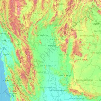
Name: Phichit Province topographic map, elevation, terrain.
Location: Phichit Province, Thailand (13.89511 97.63247 19.01511 102.75247)
Average elevation: 327 m
Minimum elevation: -2 m
Maximum elevation: 2,464 m
Other topographic maps
Click on a map to view its topography, its elevation and its terrain.
Hua Dong
Thailand > Phichit Province > Hua Dong
Hua Dong, Phichit Province, Thailand
Average elevation: 35 m
Ban Nong Na Dam
Thailand > Phichit Province > Ban Nong Na Dam
Ban Nong Na Dam, Phichit Province, Thailand
Average elevation: 37 m