
Neuquén Province topographic map
Interactive map
Click on the map to display elevation.
Neuquén Province
Mean temperatures are relatively cold for its latitude due to the high altitude. The warmest region is the eastern parts of the province where mean annual temperatures range from 13 to 15 °C (55.4 to 59.0 °F). The coldest areas are located in the Andean region where mean annual temperatures are below 5 °C (41.0 °F) or even below 0 °C (32.0 °F) at the highest peaks. During the summer months, mean December and January temperatures reach up to 24 °C (75.2 °F) in the eastern parts although during heat waves, temperatures can exceed 40 °C (104.0 °F). In July, the mean temperature ranges from 7 °C (44.6 °F) in the east to 5 °C (41.0 °F) in the west at the foothills of the Andes.
About this map
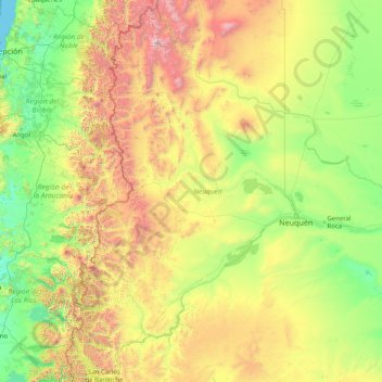
Name: Neuquén Province topographic map, elevation, terrain.
Location: Neuquén Province, Argentina (-41.10064 -71.96661 -36.05233 -67.99626)
Average elevation: 809 m
Minimum elevation: 0 m
Maximum elevation: 4,668 m
Other topographic maps
Click on a map to view its topography, its elevation and its terrain.
Aconcagua
Argentina > Mendoza > Distrito Las Cuevas
Aconcagua (Spanish pronunciation: [akoŋˈkaɣwa]) is a mountain in the Principal Cordillera of the Andes mountain range, in Mendoza Province, Argentina. It is the highest mountain in the Americas, the highest outside Asia, and the highest in both the Western Hemisphere and the Southern Hemisphere with a…
Average elevation: 6,201 m