
Chachoengsao Province topographic map
Interactive map
Click on the map to display elevation.
About this map
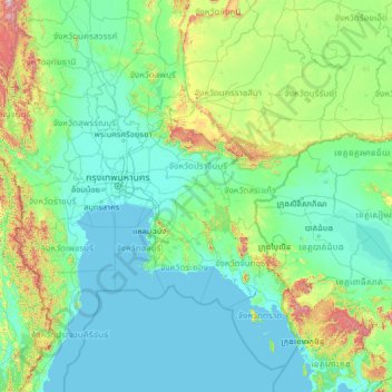
Name: Chachoengsao Province topographic map, elevation, terrain.
Location: Chachoengsao Province, Thailand (11.04932 98.98672 16.16932 104.10672)
Average elevation: 142 m
Minimum elevation: -2 m
Maximum elevation: 2,004 m
The western part of the province is the low river plain of the Bang Pa Kong River, which is used extensively for farming rice. To the east is hillier terrain, with an average elevation of more than 100 metres. In Tha Takiap District is the Khao Ang Rue Nai Wildlife Sanctuary with an area of 1,030 km2 (398 mi2).