
Quebec topographic map
Interactive map
Click on the map to display elevation.
About this map
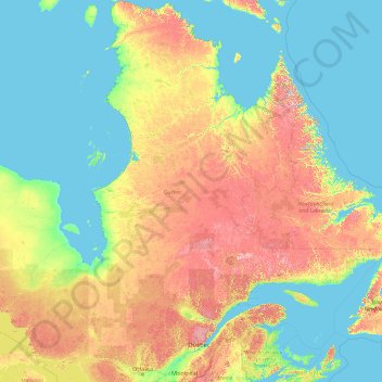
Name: Quebec topographic map, elevation, terrain.
Location: Quebec, Canada (44.99137 -79.76287 62.58250 -57.10749)
Average elevation: 195 m
Minimum elevation: -2 m
Maximum elevation: 1,383 m
Quebec's topography is very different from one region to another due to the varying composition of the ground, the climate, and the proximity to water. More than 95% of Quebec's territory, including the Labrador Peninsula, lies within the Canadian Shield. It is generally a quite flat and exposed mountainous terrain interspersed with higher points such as the Laurentian Mountains in southern Quebec, the Otish Mountains in central Quebec and the Torngat Mountains near Ungava Bay. While low and medium altitude peaks extend from western Quebec to the far north, high altitudes mountains emerge in the Capitale-Nationale region to the extreme east. Quebec's highest point at 1,652 metres (5,420 ft) is Mont d'Iberville, known in English as Mount Caubvick. In the Labrador Peninsula portion of the Shield, the far northern region of Nunavik includes the Ungava Peninsula and consists of flat Arctic tundra inhabited mostly by the Inuit. Further south is the Eastern Canadian Shield taiga ecoregion and the Central Canadian Shield forests. The Appalachian region has a narrow strip of ancient mountains along the southeastern border of Quebec.
Other topographic maps
Click on a map to view its topography, its elevation and its terrain.
Garden River No. 490
Canada > Saskatchewan > Division No. 15
Garden River No. 490, Division No. 15, Saskatchewan, Canada
Average elevation: 467 m
Metro Vancouver Regional District
Metro Vancouver Regional District, British Columbia, Canada
Average elevation: 343 m
Yellowknife
Canada > Northwest Territories > North Slave Region
Yellowknife, North Slave Region, Northwest Territories, Canada
Average elevation: 185 m
The Blue Mountains
Canada > Ontario > Grey County
The Blue Mountains, Grey County, Ontario, N0H 2P0, Canada
Average elevation: 265 m
Nobleton
Canada > Ontario > York Region > King
Nobleton, King, York Region, Golden Horseshoe, Ontario, L0G 1N0, Canada
Average elevation: 264 m
Oak Island
Canada > Nova Scotia > Avonport
Oak Island, Avonport, Municipality of the County of Kings, Kings County, Nova Scotia, B0P 1M0, Canada
Average elevation: 83 m
Waterford
Canada > Ontario > Norfolk County > Waterford
Waterford, Norfolk County, Ontario, N0E 1Y0, Canada
Average elevation: 241 m
York
Canada > Ontario > Haldimand County
York, Haldimand County, Ontario, Canada
Average elevation: 197 m
Rustico
Canada > Prince Edward Island > Lot 24
Rustico, Lot 24, Queens County, Prince Edward Island, Canada
Average elevation: 15 m
Cookville
Canada > Nova Scotia > Lunenburg County
Cookville, Municipality of the District of Lunenburg, Lunenburg County, Nova Scotia, Canada
Average elevation: 66 m
Sauble Beach
Canada > Ontario > Bruce County
Sauble Beach, South Bruce Peninsula, Bruce County, Ontario, N0H 2G0, Canada
Average elevation: 188 m
Mount Roberta
Canada > Alberta > Division No. 15
Mount Roberta, Division No. 15, Alberta, Canada
Average elevation: 2,051 m
Moab Lake
Canada > Alberta > Division No. 15
Moab Lake, Division No. 15, Alberta, Canada
Average elevation: 1,336 m
Oakland Lake
Canada > Nova Scotia > Digby County
Oakland Lake, Digby Municipal District, Digby County, Nova Scotia, Canada
Average elevation: 155 m
Porter Creek
Canada > Yukon > Whitehorse
Porter Creek, Whitehorse, Yukon, Canada
Average elevation: 710 m
Smokey Mountain
Canada > Nova Scotia > Municipality of Victoria County > Cape Smokey
Smokey Mountain, Cape Smokey, Municipality of Victoria County, Victoria County, Nova Scotia, Canada
Average elevation: 273 m
Pine Grove
Canada > Nova Scotia > Lunenburg County
Pine Grove, Municipality of the District of Lunenburg, Lunenburg County, Nova Scotia, B4V 7Y8, Canada
Average elevation: 63 m
Saint-Joseph-de-Kent
Canada > New Brunswick > Wellington Parish
Saint-Joseph-de-Kent, Wellington Parish, Kent County, New Brunswick, E4S 4G4, Canada
Average elevation: 20 m
Malcolm Island
Canada > British Columbia > Regional District of Mount Waddington > Area A (Seymour Inlet/Knight Inlet)
Malcolm Island, Area A (Seymour Inlet/Knight Inlet), Regional District of Mount Waddington, British Columbia, V0N 3E0, Canada
Average elevation: 21 m
Glencoe
Canada > Nova Scotia > Municipality of the County of Inverness
Glencoe, Municipality of the County of Inverness, Inverness County, Nova Scotia, Canada
Average elevation: 158 m
Hudson Bay Mountain
Canada > British Columbia > Regional District of Bulkley-Nechako > Area A (Hudson Bay Mountain)
Hudson Bay Mountain, Area A (Hudson Bay Mountain), Regional District of Bulkley-Nechako, British Columbia, Canada
Average elevation: 2,064 m
Burns Lake
Canada > British Columbia > Regional District of Bulkley-Nechako
Burns Lake, Regional District of Bulkley-Nechako, British Columbia, V0J 1E1, Canada
Average elevation: 942 m
Town of Mayerthorpe
Canada > Alberta > Division No. 13
Town of Mayerthorpe, Division No. 13, Alberta, T0E 1N0, Canada
Average elevation: 711 m
Loveland Lake
Canada > Ontario > Kenora District > Unorganized Kenora District
Loveland Lake, Unorganized Kenora District, Kenora District, Northwestern Ontario, Ontario, Canada
Average elevation: 426 m
Mount Esau
Canada > Alberta > Division No. 15
Mount Esau, Division No. 15, Alberta, Canada
Average elevation: 2,521 m
Ellsmere Island
Canada > Ontario > Parry Sound District > The Archipelago Township
Ellsmere Island, The Archipelago Township, Parry Sound District, Central Ontario, Ontario, Canada
Average elevation: 197 m
Domville
Canada > Ontario > Leeds and Grenville Counties > Augusta
Domville, Augusta, Leeds and Grenville Counties, Eastern Ontario, Ontario, K0E 1X0, Canada
Average elevation: 103 m
Drayton Valley
Canada > Alberta > Division No. 11
Drayton Valley, Division No. 11, Alberta, Canada
Average elevation: 839 m
West Brome
Canada > Quebec > Brome-Missisquoi > Lac-Brome
West Brome, Lac-Brome, Brome-Missisquoi, Estrie, Quebec, J0E 2P0, Canada
Average elevation: 162 m
Mount Sylvia
Canada > British Columbia > Northern Rockies Regional Municipality
Mount Sylvia, Northern Rockies Regional Municipality, British Columbia, Canada
Average elevation: 2,288 m
Hubbard Creek
Canada > Ontario > Sudbury District > Unorganized North Sudbury
Hubbard Creek, Unorganized North Sudbury, Sudbury District, Northeastern Ontario, Ontario, Canada
Average elevation: 457 m
Niagara Peninsula
Canada > Ontario > Niagara Region
Niagara Peninsula, Niagara Region, Golden Horseshoe, Ontario, Canada
Average elevation: 164 m
Caribou River
Canada > Nova Scotia > Municipality of Pictou County
Caribou River, Municipality of Pictou County, Pictou County, Nova Scotia, Canada
Average elevation: 12 m
Enterprise No. 142
Canada > Saskatchewan > Division No. 8
Enterprise No. 142, Division No. 8, Saskatchewan, Canada
Average elevation: 768 m
Hartsville
Canada > Prince Edward Island > Queens County
Hartsville, Queens County, Prince Edward Island, Canada
Average elevation: 90 m
Stanhope
Canada > Prince Edward Island > Queens County
Stanhope, Rural Municipality of North Shore, Queens County, Prince Edward Island, Canada
Average elevation: 4 m
Halifax
Canada > Nova Scotia > Halifax County
Halifax, Halifax Regional Municipality, Halifax County, Nova Scotia, Canada
Average elevation: 46 m
Township of Langley
Canada > British Columbia > Metro Vancouver Regional District
Township of Langley, Metro Vancouver Regional District, British Columbia, Canada
Average elevation: 47 m
Millcove
Canada > Prince Edward Island > Queens County
Millcove, Queens County, Prince Edward Island, Canada
Average elevation: 21 m
Negeek Lake
Canada > Ontario > Renfrew County > Madawaska Valley > Combermere
Negeek Lake, Combermere, Madawaska Valley, Renfrew County, Eastern Ontario, Ontario, Canada
Average elevation: 306 m
Albion
Canada > Prince Edward Island > Kings County
Albion, Town of Three Rivers, Kings County, Prince Edward Island, Canada
Average elevation: 13 m