
Samburu topographic map
Interactive map
Click on the map to display elevation.
About this map
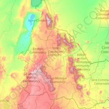
Name: Samburu topographic map, elevation, terrain.
Location: Samburu, Kenya (0.56462 36.28950 2.51323 38.07929)
Average elevation: 977 m
Minimum elevation: 275 m
Maximum elevation: 2,812 m
Other topographic maps
Click on a map to view its topography, its elevation and its terrain.
Samburu National Reserve
Kenya > Samburu > Archers Post
Samburu National Reserve, E820, Archers Post, Samburu, Kenya
Average elevation: 961 m