
Tyldesley topographic map
Interactive map
Click on the map to display elevation.
About this map
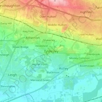
Name: Tyldesley topographic map, elevation, terrain.
Average elevation: 58 m
Minimum elevation: 12 m
Maximum elevation: 167 m
Other topographic maps
Click on a map to view its topography, its elevation and its terrain.
New Hall Farm
United Kingdom > England > Tyldesley
New Hall Farm, Tyldesley, Wigan, Greater Manchester, England, M29 7PX, United Kingdom
Average elevation: 42 m