
Mangaung Ward 45 topographic map
Interactive map
Click on the map to display elevation.
About this map
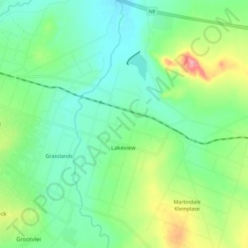
Name: Mangaung Ward 45 topographic map, elevation, terrain.
Average elevation: 1,365 m
Minimum elevation: 1,333 m
Maximum elevation: 1,438 m
Other topographic maps
Click on a map to view its topography, its elevation and its terrain.
Mangaung Ward 19
RSA > Free State > Bloemfontein
Mangaung Ward 19, Bloemfontein, Mangaung Metropolitan Municipality, Free State, 9301, RSA
Average elevation: 1,407 m
Franklin Game Reserve
RSA > Free State > Bloemfontein
Franklin Game Reserve, Naval Hill 5, Mangaung Ward 21, Bloemfontein, Mangaung Metropolitan Municipality, Free State, 9300, RSA
Average elevation: 1,421 m