
Zambezi River topographic map
Interactive map
Click on the map to display elevation.
About this map
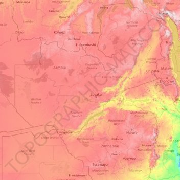
Name: Zambezi River topographic map, elevation, terrain.
Location: Zambezi River, Binga, Matabeleland North, 00236, Zimbabwe (-18.62317 22.54314 -11.07455 36.46460)
Average elevation: 1,017 m
Minimum elevation: 0 m
Maximum elevation: 2,806 m
The river flows to the southwest into Angola for about 240 kilometres (150 mi), then is joined by sizeable tributaries such as the Luena and the Chifumage flowing from highlands to the north-west. It turns south and develops a floodplain, with extreme width variation between the dry and rainy seasons. It enters dense evergreen Cryptosepalum dry forest, though on its western side, Western Zambezian grasslands also occur. Where it re-enters Zambia it is nearly 400 metres (1,300 ft) wide in the rainy season and flows rapidly, with rapids ending in the Chavuma Falls, where the river flows through a rocky fissure. The river drops about 400 metres (1,300 ft) in elevation from its source at 1,500 metres (4,900 ft) to the Chavuma Falls at 1,100 metres (3,600 ft), in a distance of about 400 kilometres (250 mi). From this point to the Victoria Falls, the level of the basin is very uniform, dropping only by another 180 metres (590 ft) in a distance of around 800 kilometres (500 mi).
Other topographic maps
Click on a map to view its topography, its elevation and its terrain.
Tsholotsho
Tsholotsho, Matabeleland North, Zimbabwe
Average elevation: 1,047 m
Hwange
Hwange, Matabeleland North, 00236, Zimbabwe
Average elevation: 968 m
Hwange National Park
Hwange National Park, Hwange, Matabeleland North, Zimbabwe
Average elevation: 1,000 m
Victoria Falls
Victoria Falls, Hwange, Matabeleland North, 00236, Zimbabwe
Average elevation: 877 m