
Chinsali topographic map
Interactive map
Click on the map to display elevation.
About this map
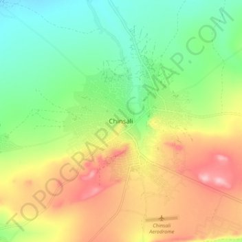
Name: Chinsali topographic map, elevation, terrain.
Location: Chinsali, Chinsali District, Muchinga Province, Zambia (-10.58997 32.02608 -10.50997 32.10608)
Average elevation: 1,294 m
Minimum elevation: 1,219 m
Maximum elevation: 1,398 m
The geographical coordinates of Chinsali Town are 10°33'08.0"S, 32°04'09.0"E (Latitude:-10.552222; Longitude:32.069167). The town is nestled at an average elevation of 1,383 metres (4,537 ft) above mean sea level.
Other topographic maps
Click on a map to view its topography, its elevation and its terrain.
Isoka
Zambia > Muchinga Province > Isoka
Isoka, Isoka District, Muchinga Province, Zambia
Average elevation: 1,376 m
Chambeshi
Zambia > Muchinga Province > Chambeshi
Chambeshi, Muchinga Province, Zambia
Average elevation: 1,192 m