
Horst aan de Maas topographic map
Interactive map
Click on the map to display elevation.
About this map
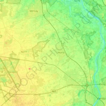
Name: Horst aan de Maas topographic map, elevation, terrain.
Location: Horst aan de Maas, Limburg, Netherlands (51.37805 5.87497 51.52478 6.17898)
Average elevation: 27 m
Minimum elevation: 9 m
Maximum elevation: 50 m
Dutch Topographic map of the municipality of Horst aan de Maas, June 2015.
Other topographic maps
Click on a map to view its topography, its elevation and its terrain.
Maastricht
Netherlands > Limburg > Maastricht
Maastricht, Limburg, Netherlands, 6211CS, Netherlands
Average elevation: 101 m
Dagstrand De Grote Hegge
Netherlands > Limburg > Thorn
Dagstrand De Grote Hegge, Thorn, Maasgouw, Limburg, Netherlands
Average elevation: 24 m