
Aït Yacoub topographic map
Interactive map
Click on the map to display elevation.
About this map
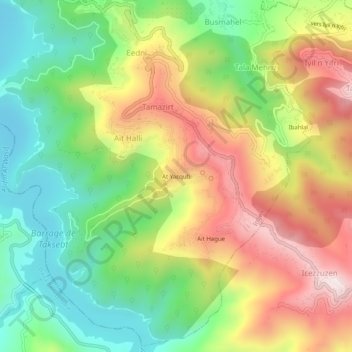
Name: Aït Yacoub topographic map, elevation, terrain.
Average elevation: 391 m
Minimum elevation: 101 m
Maximum elevation: 762 m
Other topographic maps
Click on a map to view its topography, its elevation and its terrain.
Barrage de Taksebt
Algérie > Tizi Ouzou > Daïra Larbaa N'Aït Irathen > Irdjen > Aït Halli
Barrage de Taksebt, Aït Halli, Irdjen, Daïra Larbaa N'Aït Irathen, Tizi Ouzou, Algérie
Average elevation: 353 m