
Gesundbrunnen topographic map
Interactive map
Click on the map to display elevation.
About this map
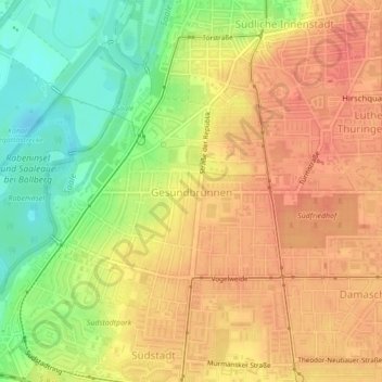
Name: Gesundbrunnen topographic map, elevation, terrain.
Location: Gesundbrunnen, Halle (Saale), Saxony-Anhalt, Germany (51.45430 11.94743 51.47140 11.97212)
Average elevation: 102 m
Minimum elevation: 70 m
Maximum elevation: 121 m
Other topographic maps
Click on a map to view its topography, its elevation and its terrain.
Halle (Saale)
Germany > Saxony-Anhalt > Halle (Saale)
Halle (Saale), Saxony-Anhalt, 06108, Germany
Average elevation: 114 m