La Teste-de-Buch topographic map
Interactive map
Click on the map to display elevation.
About this map
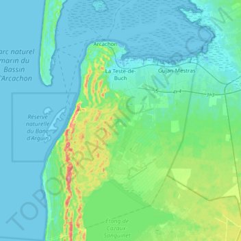
Name: La Teste-de-Buch topographic map, elevation, terrain.
Average elevation: 14 m
Minimum elevation: -2 m
Maximum elevation: 85 m

Click on the map to display elevation.
Name: La Teste-de-Buch topographic map, elevation, terrain.
Average elevation: 14 m
Minimum elevation: -2 m
Maximum elevation: 85 m