
Anderson County topographic map
Interactive map
Click on the map to display elevation.
About this map
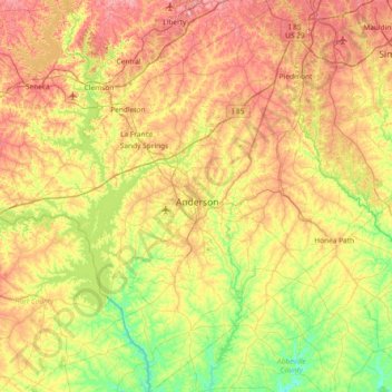
Name: Anderson County topographic map, elevation, terrain.
Location: Anderson County, South Carolina, USA (34.20875 -82.99207 34.81953 -82.31387)
Average elevation: 229 m
Minimum elevation: 136 m
Maximum elevation: 357 m
Other topographic maps
Click on a map to view its topography, its elevation and its terrain.
Tenmile
USA > South Carolina > Tenmile
Tenmile, Charleston County, South Carolina, 29416, USA
Average elevation: 9 m
Cape Romain National Wildlife Refuge
USA > South Carolina > Awendaw
Cape Romain National Wildlife Refuge, Awendaw, Charleston County, South Carolina, USA
Average elevation: 3 m
Simmonsville
USA > South Carolina > Simmonsville
Simmonsville, Georgetown County, South Carolina, USA
Average elevation: 5 m
Grenadier
USA > South Carolina > Grenadier
Grenadier, Lexington County, South Carolina, 29210, USA
Average elevation: 74 m
Greer
USA > South Carolina > Greer
Greer, Greenville County, South Carolina, USA
Average elevation: 279 m
Pine Creek
USA > South Carolina > Pine Creek
Pine Creek, Kershaw County, South Carolina, 29020, USA
Average elevation: 73 m