
Alberton topographic map
Interactive map
Click on the map to display elevation.
Alberton
Alberton lies at an elevation of approximately 1,570 m (5,150 ft) above sea level on the banks of the Natal Spruit, approximately 11 km south-east of Johannesburg CBD, 59 km south of Pretoria and 49 km north-east of Vereeniging. Organisationally and administratively, it is included in the City of Ekurhuleni Metropolitan Municipality.
About this map
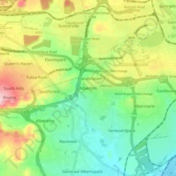
Name: Alberton topographic map, elevation, terrain.
Average elevation: 1,617 m
Minimum elevation: 1,531 m
Maximum elevation: 1,792 m
Other topographic maps
Click on a map to view its topography, its elevation and its terrain.
Daveyton
South Africa > Gauteng > City of Ekurhuleni Metropolitan Municipality
Average elevation: 1,613 m
Daveyton
South Africa > Gauteng > City of Ekurhuleni Metropolitan Municipality
Average elevation: 1,613 m
Etwatwa
South Africa > Gauteng > City of Ekurhuleni Metropolitan Municipality
Average elevation: 1,611 m
Bill Stewart Nature Reserve
South Africa > Gauteng > City of Ekurhuleni Metropolitan Municipality
Average elevation: 1,695 m