
Thank you for supporting this site ❤️
Make a donation
Make a donation
Hoedspruit topographic map
Click on the map to display elevation.
Thank you for supporting this site ❤️
Make a donation
Make a donation
About this map
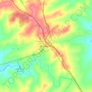
Name: Hoedspruit topographic map, elevation, terrain.
Average elevation: 524 m
Minimum elevation: 485 m
Maximum elevation: 569 m
Thank you for supporting this site ❤️
Make a donation
Make a donation
Other topographic maps
Click on a map to view its topography, its elevation and its terrain.
Maruleng Ward 6
South Africa > Limpopo > Mopani District Municipality > Maruleng Local Municipality
Average elevation: 496 m
Zandspruit
South Africa > Limpopo > Mopani District Municipality > Maruleng Local Municipality
Average elevation: 541 m