
Matatiele topographic map
Interactive map
Click on the map to display elevation.
About this map
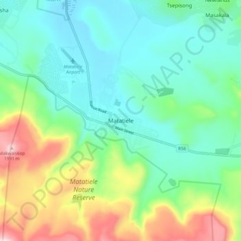
Name: Matatiele topographic map, elevation, terrain.
Average elevation: 1,603 m
Minimum elevation: 1,437 m
Maximum elevation: 2,021 m
Other topographic maps
Click on a map to view its topography, its elevation and its terrain.
Cedarville
South Africa > Eastern Cape > Alfred Nzo District Municipality > Matatiele Local Municipality
Cedarville, Matatiele Local Municipality, Alfred Nzo District Municipality, Eastern Cape, South Africa
Average elevation: 1,495 m
Cedarberg
South Africa > Eastern Cape > Alfred Nzo District Municipality > Matatiele Local Municipality
Cedarberg, Matatiele Local Municipality, Alfred Nzo District Municipality, Eastern Cape, South Africa
Average elevation: 1,634 m