
Bonn topographic map
Interactive map
Click on the map to display elevation.
About this map
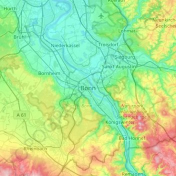
Name: Bonn topographic map, elevation, terrain.
Location: Bonn, Noordrijn-Westfalen, 53111, Duitsland (50.57585 6.94066 50.89585 7.26066)
Average elevation: 138 m
Minimum elevation: 40 m
Maximum elevation: 433 m
Other topographic maps
Click on a map to view its topography, its elevation and its terrain.
Lengsdorf
Duitsland > Noordrijn-Westfalen > Bonn
Lengsdorf, Hardtberg, Bonn, Noordrijn-Westfalen, 53127, Duitsland
Average elevation: 115 m
Kessenich
Duitsland > Noordrijn-Westfalen > Bonn
Kessenich, Stadtbezirk Bonn, Bonn, Noordrijn-Westfalen, 53129, Duitsland
Average elevation: 84 m
St. Adelheid-Brunnen
Duitsland > Noordrijn-Westfalen > Bonn
St. Adelheid-Brunnen, Brunnenweg, Pützchen, Pützchen/Bechlinghoven, Bonn-Beuel, Bonn, Noordrijn-Westfalen, 53229, Duitsland
Average elevation: 77 m