
Coos County topographic map
Interactive map
Click on the map to display elevation.
About this map
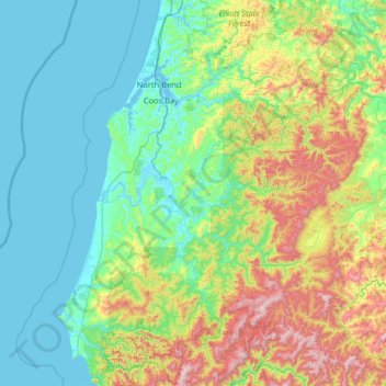
Name: Coos County topographic map, elevation, terrain.
Location: Coos County, Oregon, United States of America (42.66638 -124.55228 43.61145 -123.70156)
Average elevation: 266 m
Minimum elevation: -3 m
Maximum elevation: 1,257 m
Other topographic maps
Click on a map to view its topography, its elevation and its terrain.
Cascade Range
United States of America > Oregon
Cascade Range, Jefferson County, Oregon, United States of America
Average elevation: 1,281 m
Lakeview
United States of America > Oregon > Lakeview
Lakeview, Lake County, Oregon, 97630, United States of America
Average elevation: 1,523 m
Crook County
United States of America > Oregon
Crook County, Oregon, United States of America
Average elevation: 1,339 m
Hood River
United States of America > Oregon > Hood River > Hood River
Hood River, Hood River County, Oregon, United States of America
Average elevation: 112 m
Hillsboro
United States of America > Oregon > Hillsboro
Hillsboro, Washington County, Oregon, United States of America
Average elevation: 53 m