
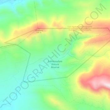
Salmonsdam Nature Reserve topographic map
Interactive map
Click on the map to display elevation.
About this map
Name: Salmonsdam Nature Reserve topographic map, elevation, terrain.
Average elevation: 343 m
Minimum elevation: 65 m
Maximum elevation: 803 m
Other topographic maps
Click on a map to view its topography, its elevation and its terrain.
Overstrand Ward 8
RSA > Western Cape > Overstrand Local Municipality
Overstrand Ward 8, Overstrand Local Municipality, Overberg District Municipality, Western Cape, RSA
Average elevation: 144 m
Walker Bay Nature Reserve
RSA > Western Cape > Overstrand Local Municipality
Walker Bay Nature Reserve, Overstrand Ward 11, Overstrand Local Municipality, Overberg District Municipality, Western Cape, RSA
Average elevation: 54 m
Overstrand Ward 10
RSA > Western Cape > Overstrand Local Municipality
Overstrand Ward 10, Overstrand Local Municipality, Overberg District Municipality, Western Cape, 7141, RSA
Average elevation: 213 m
Maanschynkop Nature Reserve
RSA > Western Cape > Overstrand Local Municipality
Maanschynkop Nature Reserve, R43, Overstrand Ward 3, Overstrand Local Municipality, Overberg District Municipality, Western Cape, 7210, RSA
Average elevation: 538 m
Rooiels River
RSA > Western Cape > Overstrand Local Municipality
Rooiels River, Overstrand Local Municipality, Overberg District Municipality, Western Cape, RSA
Average elevation: 103 m
Fernkloof Nature Reserve
RSA > Western Cape > Overstrand Local Municipality
Fernkloof Nature Reserve, Rotary Way Extension, Overstrand Ward 3, Overstrand Local Municipality, Overberg District Municipality, Western Cape, 7200, RSA
Average elevation: 237 m
Three Sisters
RSA > Western Cape > Overstrand Local Municipality
Three Sisters, Overstrand Local Municipality, Overberg District Municipality, Western Cape, 7195, RSA
Average elevation: 306 m
Babilonstoring Nature Reserve
RSA > Western Cape > Overstrand Local Municipality
Babilonstoring Nature Reserve, Black Route (Long), Hemel & Aarde MTB, Overstrand Ward 4, Overstrand Local Municipality, Overberg District Municipality, Western Cape, RSA
Average elevation: 374 m
Boesmans River
RSA > Western Cape > Overstrand Local Municipality
Boesmans River, Overstrand Local Municipality, Overberg District Municipality, Western Cape, 7271, RSA
Average elevation: 121 m
Quoin Point Nature Reserve
RSA > Western Cape > Overstrand Local Municipality
Quoin Point Nature Reserve, R43, Overstrand Ward 11, Overstrand Local Municipality, Overberg District Municipality, Western Cape, RSA
Average elevation: 12 m