
Lolland topographic map
Interactive map
Click on the map to display elevation.
About this map
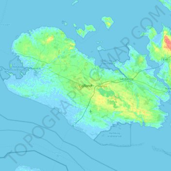
Name: Lolland topographic map, elevation, terrain.
Location: Lolland, Lolland Municipality, Region Zealand, Denmark (54.59375 10.95471 54.96074 11.86672)
Average elevation: 2 m
Minimum elevation: -6 m
Maximum elevation: 38 m
Other topographic maps
Click on a map to view its topography, its elevation and its terrain.
Snap-ind
Denmark > Region Zealand > Snap-ind
Snap-ind, Lolland Municipality, Region Zealand, 4941, Denmark
Average elevation: 4 m
Falster
Falster, Guldborgsund Municipality, Region Zealand, Denmark
Average elevation: 3 m
Lindholm
Lindholm, Vordingborg Municipality, Region Zealand, Denmark
Average elevation: 0 m
Zealand
Zealand, Holbæk Municipality, Region Zealand, Denmark
Average elevation: 12 m
Omø
Omø, Slagelse Municipality, Region Zealand, 4245, Denmark
Average elevation: 1 m