
Djebla topographic map
Interactive map
Click on the map to display elevation.
About this map
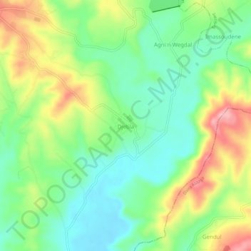
Name: Djebla topographic map, elevation, terrain.
Location: Djebla, Ouaguenoun, Daïra Ouaguenoun, Tizi Ouzou, 15623, Algérie (36.73190 4.18248 36.77190 4.22248)
Average elevation: 169 m
Minimum elevation: 106 m
Maximum elevation: 270 m
Other topographic maps
Click on a map to view its topography, its elevation and its terrain.
Laziv Ouheddadh
Algérie > Tizi Ouzou > Daïra Ouaguenoun > Ouaguenoun
Laziv Ouheddadh, Ouaguenoun, Daïra Ouaguenoun, Tizi Ouzou, 15144, Algérie
Average elevation: 317 m