
Sneeuberg topographic map
Interactive map
Click on the map to display elevation.
About this map
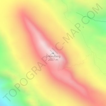
Name: Sneeuberg topographic map, elevation, terrain.
Average elevation: 1,542 m
Minimum elevation: 927 m
Maximum elevation: 2,005 m
Other topographic maps
Click on a map to view its topography, its elevation and its terrain.
Cederberg Wilderness Area
South Africa > Western Cape > Cederberg Local Municipality
Cederberg Wilderness Area, Cederberg Ward 1, Cederberg Local Municipality, West Coast District Municipality, Western Cape, South Africa
Average elevation: 726 m
Graafwater
South Africa > Western Cape > Cederberg Local Municipality > Graafwater
Graafwater, Cederberg Local Municipality, West Coast District Municipality, Western Cape, South Africa
Average elevation: 197 m