
Elko County topographic map
Interactive map
Click on the map to display elevation.
About this map
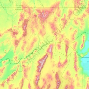
Name: Elko County topographic map, elevation, terrain.
Location: Elko County, Nevada, United States (40.11784 -117.01775 42.00221 -114.03965)
Average elevation: 1,838 m
Minimum elevation: 1,283 m
Maximum elevation: 3,337 m
According to the U.S. Census Bureau, the county has a total area of 17,203 square miles (44,560 km2), of which 17,170 square miles (44,500 km2) is land and 33 square miles (85 km2) (0.2%) is water. Not counting Alaska's boroughs (four of which are also larger), it is the fourth-largest county in area in the United States (behind San Bernardino County, California, Coconino County, Arizona, and Nye County, Nevada). The elevation ranges from about 4,300 feet (1,300 m) at the edge of the salt flats of the Great Salt Lake Desert, to 11,387 feet (3,471 m) on the summit of Ruby Dome in the Ruby Mountains. The most topographically prominent mountain in Elko County is Pilot Peak.
Other topographic maps
Click on a map to view its topography, its elevation and its terrain.
Henderson
United States > Nevada > Clark County
Henderson, Clark County, Nevada, United States
Average elevation: 691 m
Pahrump
United States > Nevada > Nye County
Pahrump, Nye County, Nevada, United States
Average elevation: 1,141 m