
Vanderkloof Dam topographic map
Interactive map
Click on the map to display elevation.
About this map
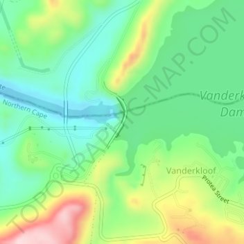
Name: Vanderkloof Dam topographic map, elevation, terrain.
Average elevation: 1,188 m
Minimum elevation: 1,095 m
Maximum elevation: 1,365 m
Other topographic maps
Click on a map to view its topography, its elevation and its terrain.
Koffiefontein
South Africa > Free State > Xhariep District Municipality > Letsemeng Local Municipality
Average elevation: 1,203 m
Paardeberg
South Africa > Free State > Xhariep District Municipality > Letsemeng Local Municipality
Average elevation: 1,168 m
Jacobsdal
South Africa > Free State > Xhariep District Municipality > Letsemeng Local Municipality
Average elevation: 1,147 m