
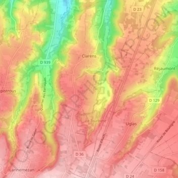
Clarens topographic map
Interactive map
Click on the map to display elevation.
About this map
Name: Clarens topographic map, elevation, terrain.
Average elevation: 535 m
Minimum elevation: 403 m
Maximum elevation: 605 m
Other topographic maps
Click on a map to view its topography, its elevation and its terrain.
Clarets
France > Occitania > Hautes Pyrenees > Viella
Clarets, Viella, Argelès-Gazost, Hautes Pyrenees, Occitania, Metropolitan France, 65120, France
Average elevation: 1,170 m
Bagnères-de-Bigorre
France > Occitania > Hautes Pyrenees > Bagnères-de-Bigorre
Bagnères-de-Bigorre, Hautes Pyrenees, Occitania, Metropolitan France, France
Average elevation: 1,332 m